
Description of distance and length
For GPS record please go to the German Version click
GSL Veitsch Strecke auf einer größeren Karte anzeigen
The distance leads to a large extent along the Veitscher municipality border. The start is on 670m, the highest point (Graf-Meran-House) on 1860m, sea-level.
Only the first and the last 1.5 km of the distance are asphalted, the remaining 51 km are gravel roads, wood and marked alpine ways.
There are 12 refreshment places, where you receive tea, water, cola, isostar, dried fruit, bananas and dressing material, at the changing points additionally still home-made cakes.

Marking
On roads and ways there are yellow soil markings; on the race day there are additionally at unclear places yellow tapes and banners attached.
The marathon track
The whole distance consists of three parts: Marathon 54.0 km;
Relay: 1st runner 16.5 km / 2nd runner: 16.0 km / 3rd runner: 21.5 km
(for new categories please refer to About)
First distance
The distance and length is the original one. Please check every time also the German Version and the information on the running day! Small changes of the parts can be possible.
16.5 km / Start 670 m / Finish 1280 m / 3 refreshment areas

Second distance
16 km / Start 1280 m / Finish 1451 m / 3 refreshment areas

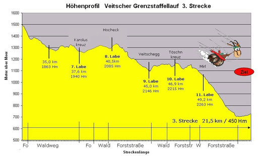
Third distance
21.5 km / Start 1451 m / Finish 670 m / 6 refreshment areas
The chart already includes the new route at the Hockeck.
-> please also refer to the German Webpage "Strecke"